Capabilities Viewer
Metadaten
Technische Details
Metadaten
| Name | WMS |
| Titel | Höheninformationen Sachsen |
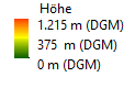
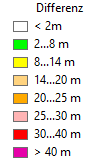
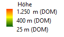
| Kurzbeschreibung | Das Digitale Höhenmodelle (DHM) beschreibt die Oberfläche des Geländes durch dreidimensionale Koordinaten einer repräsentativen Menge an Bodenpunkten (nur die Erdoberfläche) oder Nichtbodenpunkten (u.a. Vegetation, Gebäude). Es gliedert sich auf in das Digitale Geländemodell (DGM) und Digitales Oberflächenmodell (DOM). Oberflächenpunkte, wie z.B. Gebäude und Vegetation sind in diesem Modell nicht enthalten sondern werden im digitalen Oberflächenmodell (DOM) geführt. Die Abfrage der Geländehöhe, Höhe der Oberfläche sowie die Reliefdarstellungen (Schummerungsbild) des DGM und DOM basieren auf den DGM2/DOM2 Daten mit einer Bodenauflösungen von ca. 2 m (Höhenangabe in Meter im Höhenreferenzsystem DHHN2016 - AdV-Namespace 'DE_DHHN2016_NH', EPSG-Code 7837). In Teilen von Sachsen stehen bereits Daten mit 1 Meter Auflösung zur Verfügung. Die Primärdaten der digitalen Geländemodelle DGM / DOM wurden durch Laserscanner-Messaufnahme erfasst. Die Abfrage der Geländehöhe, Höhe der Oberfläche sowie der Höhendifferenz (normalisiertes DOM - nDOM) erfolgt über die Sachdatenabfrage (GetFeatureInfo). Verwenden Sie alle Kartenebenen (Layer) dieses Dienstes, setzen Sie die Kartenebenen in Ihrer Anwendung (Client) halbtransparent um das Relief zu erkennen.Das Digitale Höhenmodelle (DHM) beschreibt die Oberfläche des Geländes durch dreidimensionale Koordinaten einer repräsentativen Menge an Bodenpunkten (nur die Erdoberfläche) oder Nichtbodenpunkten (u.a. Vegetation, Gebäude). Es gliedert sich auf in das Digitale Geländemodell (DGM) und Digitales Oberflächenmodell (DOM). Oberflächenpunkte, wie z.B. Gebäude und Vegetation sind in diesem Modell nicht enthalten sondern werden im digitalen Oberflächenmodell (DOM) geführt. Die Abfrage der Geländehöhe, Höhe der Oberfläche sowie die Reliefdarstellungen (Schummerungsbild) des DGM und DOM basieren auf den DGM2/DOM2 Daten mit einer Bodenauflösungen von 2 x 2 m (Höhenangabe in Meter im Höhenreferenzsystem DHHN2016 - AdV-Namespace 'DE_DHHN2016_NH', EPSG-Code 7837). In Teilen von Sachsen stehen bereits Daten mit 1 x 1 Meter Auflösung zur Verfügung. Die Primärdaten der digitalen Geländemodelle DGM / DOM wurden durch Laserscanner-Messaufnahme erfasst. Die Abfrage der Geländehöhe, Höhe der Oberfläche sowie der Höhendifferenz (normalisiertes DOM - nDOM) erfolgt über die Sachdatenabfrage (GetFeatureInfo). Verwenden Sie alle Kartenebenen (Layer) dieses Dienstes, setzen Sie die Kartenebenen in Ihrer Anwendung (Client) halbtransparent um das Relief zu erkennen. Die Reliefdarstellung (Schummerung) mit Überhöhung ermöglicht die Erzeugung eines Kartenbildes mit 3D Effekt wenn die darüberliegenden Fachdatenlayer z.B. WebAtlasSN halbtransparent angezeigt werden. Die Höhenlinien wurden aus dem Digitalen Geländemodell (DGM) - Freistaat Sachsen automatisch abgeleitet, haben eine Äquidistanz von 2,5 Metern und sind nicht kartographisch aufbereitet. Die aufgrund der kachelweisen Erzeugung generierten Höhenlinien wurden zusammengefasst und geglättet und sind der Ausgangspunkt für die Erstellung der Höhenlinien der Digitalen Topographischen Karten (DTK). Über die Kartenebene Beschriftung, können Ausdrucke mit einem beschrifteten Raster des DGM erzeugt werden. Weiterhin stehen Informationen zur Hangneigung und zur Geländeveränderung zur Verfügung.
Die Reliefdarstellung (Schummerung) mit Überhöhung ermöglicht die Erzeugung eines Kartenbildes mit 3D Effekt wenn die darüberliegenden Fachdatenlayern z.B. WebAtlasSN halbtransparent angezeigt werden.
Die Höhenlinien wurden aus dem Digitalen Geländemodell (DGM) - Freistaat Sachsen automatisch abgeleitet, haben eine Äquidistanz von 2,5 Metern und sind nicht kartographisch aufbereitet. Die Aufgrund der kachelweisen Erzeugung generierten Höhenlinien wurden zusammengefasst und geglättet und stellen den Ausgangspunkt für die Erstellung der Höhenlinien der Digitalen Topographischen Karten (DTK) dar.
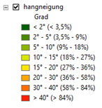
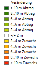
Über die Kartenebene Beschriftung, können Ausdrucke mit einem beschrifteten Raster des DGM erzeugt werden. Über die Kartenebene Beschriftung können Ausdrucke mit einem beschrifteten Raster des DGM erzeugt werden. Weiterhin stehen Informationen zur Hangneigung und zur Geländeveränderung zur Verfügung.
Weitere Informationen zum Dienst erhalten Sie im GeoMIS.Sachsen oder über die Metadatenanzeige welche über folgende URL direkt aufrufbar ist: https://geoportal.sachsen.de/cps/metadaten_portal.html?id=5e0f6071-008e-4d57-810e-48a8362acf04. |
| KeywordList |
|
| Online Quelle |
|
| Kontaktinformationen |
|
| Gebühren | Die Nutzung ist kostenfrei unter Angabe der Quelle “Landesamt für Geobasisinformation Sachsen (GeoSN)”. (https://geoportal.sachsen.de/cps/geosn.html) |
| Zugriffseinschränkungen | Es gelten keine Zugriffsbeschränkungen. (https://geoportal.sachsen.de/cps/geosn.html) |
| MaxWidth | 4096 |
| MaxHeight | 4096 |
Technische Details
| Request |
|
| Fehlermeldung |
|
| Kartenebene |
|